
Today’s Task
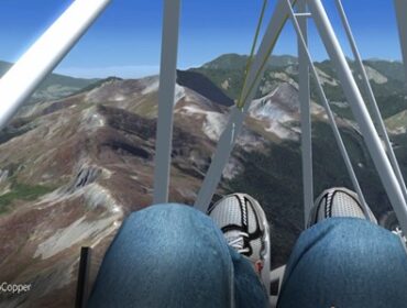
We setup a task to fly from Junction Butte, CO to Silverthorne CO. This is about a 50km task and pretty much has a high alpine ridge to fly most of the task course line.
Junction Butte itself is a North – Northwest facing launch and the Williams Peak/Ute Peak range is best in a West wind, but does provide some lift in a North West. We configured a very strong West wind to start that would change more northerly as the day progresses. This should provide us with a quartering tail wind most of the flight.
Landing is anticipated to be in the town of Silverthorn at the local dog park. There is not much open spaces in town and this site is very restricted!
We get a late start
We choose a late start time, about 2:00 PM. Winds are quite strong but still westerly. BlueXDragon launches first and quickly top lands. The north facing launch we have chosen is not the place to be! We trundle over the west launch which appears to be much more straightforward.
Seagull launches first and is finding only marginal lift. BlueXDragon launches soon after. Seagull catches a thermal near launch and attempts to make it back to the main ridge. This proves more difficult than it looks like an he struggles with some low ridges but does eventually make it to the main ridge. BlueXDragon on the other hand does not get a thermal and soars the Butte for quite some time until he just decides to make a dive downwind and hope to catch something on the low ridges.
Sometimes you eat the bear, sometimes the bear eats you
Seagull start gaining some altitude and gets into much better air above the ridge. At points even making it to cloud base which is about 12,000 ft. and fairly overcast. At the first real challenge, jumping the gap from the Williams Peak range to Ute Peak, it looks to maybe be unmakeable in the late afternoon weather. Once he goes for it, it is actually lifting pretty good in the gap and he makes it across with no dramas!
BlueXDragon suffered a different fate. He did get some ragged lift in the low hills and even managed to make it to the base of the main ridge, but luck did not favor him today. He ended up landing near the base of the ridge a good distance from any road or pickup. It would be long, cold, evening of waiting in the dark once he hiked his glider out of that landing.
Seagull was able to continue down range and made the final turn point at Ptarmington Peak just above Silverthorne overlooking the town, Dillon Reservoir, and I-70 heading up towards the Eisenhower Tunnel. He locates that Rainbow Dog park and heads out to end a very nice XC.

It starts to get dark
We started to get a cool looking sunset at this point! We had not realized that even though we setup our Scenario for July, we started the multi-player session as the current date! May! Sun sets early in spring.

Seagull has to work pretty hard at getting down at this point. The winds had picked up considerably and even small ridges were providing lift. Darkness was approaching too! Seagull was in a race against time!
This is always exciting. He pulled it off with a stand up landing right next to the sock. Almost hovered in.

Conclusions
This was our first flight from this site, and I think we both found the site to be both fun and challenging. I think we may change the main launch to be the west launch that we ultimately used. But, this show how important it is when hang gliding to be able to ground handle a glider around a site. We also thought the photo real as pretty good for this area considering we are flying FSX. We learned that multiplayer date/time cannot be overwritten using the API from The Hang Gliding Files app. Seagull also pointed out that some of the turn points might be better placed and are too far back on the ridge. This is also an issue when translating from Google Earth to FSX. FSX is not that accurate!


 Would we fly here again? SURE! Great fun.