This was one of our best flights to date. Not because it was the longest, or highest (might be), or even the prettiest. No, it was just very realistic. I mean that in the most basic of terms, to be sure, but realistic in that we captured what was essentially a ‘Hang Glider Flight’.
You can watch the flight here: YouTube
We did not do any development or debugging or must have tweak settings or have to download something or start over multiple times. Nope. We just fired up the Simulator, started a multiplayer session, cranked up the app and teleported to a new launch. I had not flown here in either real life or in the simulator, but Seagull has flown here in real life a few times. Neither of us had ever flown in the weather scenario we had captured. We were going to find out what this place was like by discovery. Simulated of course, but what we look for: is the experience, not the techniques or hardware or software. We will analyze that later.
So, I am going to write this up as a typical flight report but along the way I will demonstrate some of the technology we used and some differences with some newer tech. The point here is to show that not only can we hang glide, but that we are heading into something completely different. This is the high-water mark for our current experiment. One must know where you started to judge and evaluate where you end up. This is the first time we have a goal post to start from and benchmark our efforts going forward.
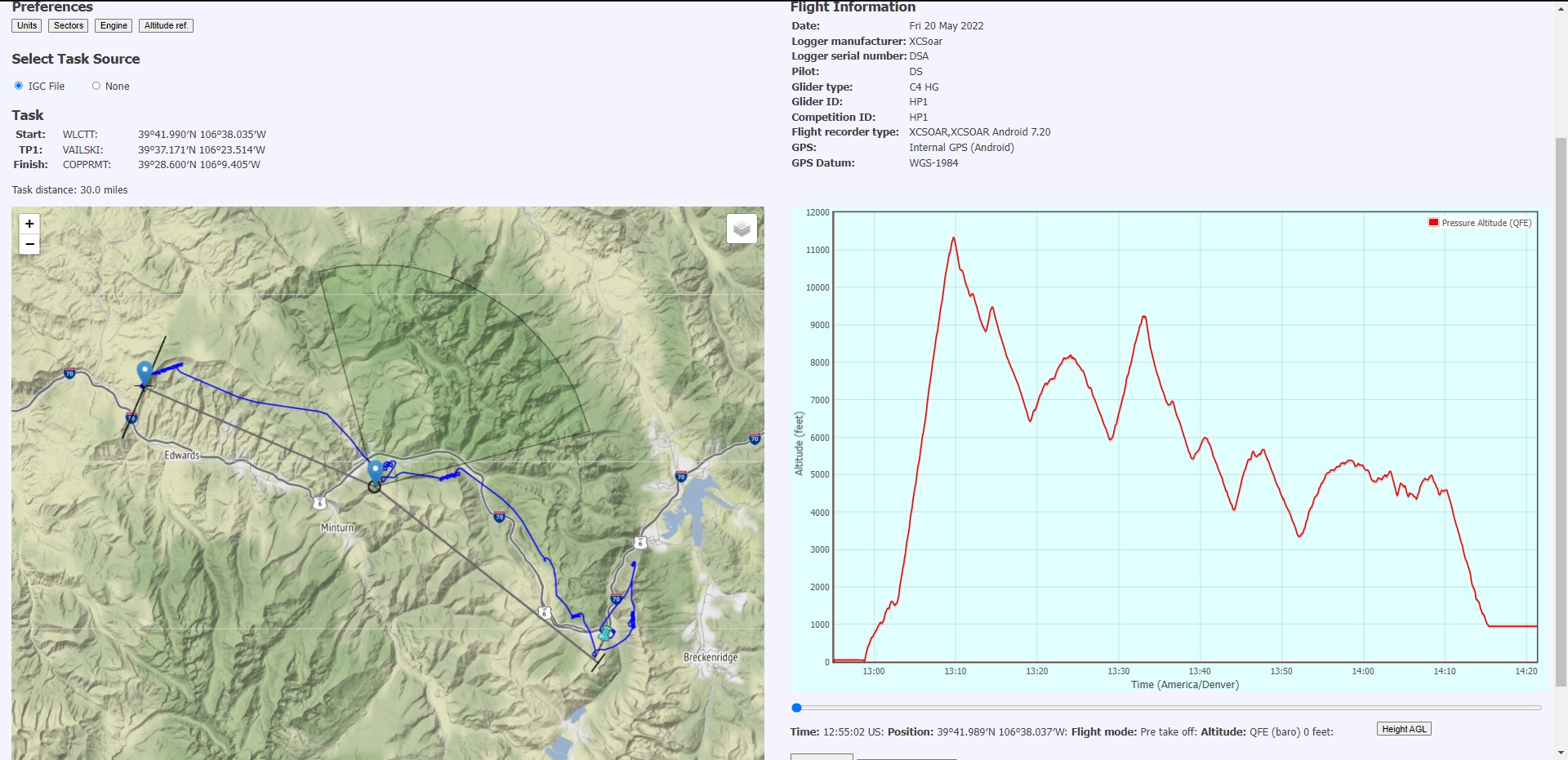
Wolcott, Colorado
Our flight today is from the site just outside Wolcott. Wolcott is west of the town of Vail along Interstate 70. Past Wolcott, you leave the western slope type alpine terrain and start into the western desert country. You can see that in the video. After a ride up the dirt road to launch, you set up on top of the ridge and look out generally straight west with I-70 directly in front.
We are going to fly a pre-recorded weather scenario. We use the app to record all the weather reports for every weather station within a 150-mile radius of the launch. We have one report for every 15 minutes during a typical flying day. This includes wind, cloud cover, temperature, etc. This gives us dynamic weather over both time and distance. We can only choose our launch time and hope that is going to be in a good part of the day.
We start on July 4, 2021, 1:45 PM. Temperature is 79 F and dew point is 15 F. This makes for a very high cloud base (over 20,000 ft.). This is not uncommon in Colorado summers, but it is not the norm. Winds are 255 Degrees at 14 kts. This a good amount of wind, but not too much, straight into launch and giving us incentive to go downwind over the back. This would be an optimal wind speed and direction for this site in real life.
We load up our task for the day into our flight computers: Wolcott to Vail to Copper Mountain. 55 Km flight over some very inhospitable country. Scary.
Launch
I am flying Aeros Combat C4 and Seagull is flying the Brightstar Swift. I launch first and settle into some decent ridge lift.

Seagull is off not much after me and we are soon both climbing right out. Very good thermals to start with! That makes the Go decision very easy. I am the first to turn downwind heading for the first turn point of Vail. We are both very high to start. I leave at around 17,000 ft. but climb to over 18,000 ft. just gliding west! Seagull climbs to about 20,000 ft. right over the launch and even gets a bit disoriented at that height. But he turns downwind too and races past me toward Vail. His glider has superior glide and speed performance as it is a rigid wing glider.
Vail Ski Area
After a slight veer to catch the turn point cylinder, he heads for Vail pass. A long stretch of non-landable territory. There are open areas, but it would be exceedingly difficult to land there. The altitude makes the air very thin, and the ground is no where near flat and there are big boulders in every field. You will crash here in real-life, no matter how good you are.
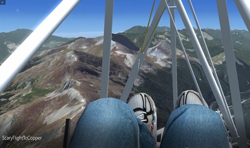
I fly by the turn point and then must fly back upwind to catch the cylinder. What happened next, is I literally got lost. I just lost my bearings. I was not where I thought I was and it took me quite awhile of flying in the wrong direction before I understood what I was doing. This sounds crazy, but it happens all the time. When you are circling a lot and over unfamiliar territory and at high altitudes, it is hard to make a correct mental map with you in it. By the time I figured out what/where I was, I was way behind both in task distance but also behind the Vail Mountain! I attempted to go straight toward the pass but could not glide over Vail and start plummeting down into the back bowls. This would be life-threatening in real-life. It might be possible to survive a landing back there, but probably not. I luck into a thermal on the back side and get very high again to continue to Copper. In VR, this would have been very scary.
Copper Mountain Ski Area
By this time, Seagull had already crossed the pass and even had made goal flying over the top of Copper ski area. He continued across the valley to the Ten Mile range and ridge soared the entire range a few times waiting for me to catch up. I eventually did make the Copper finish, but very low and just enough altitude to fly to the LZ.
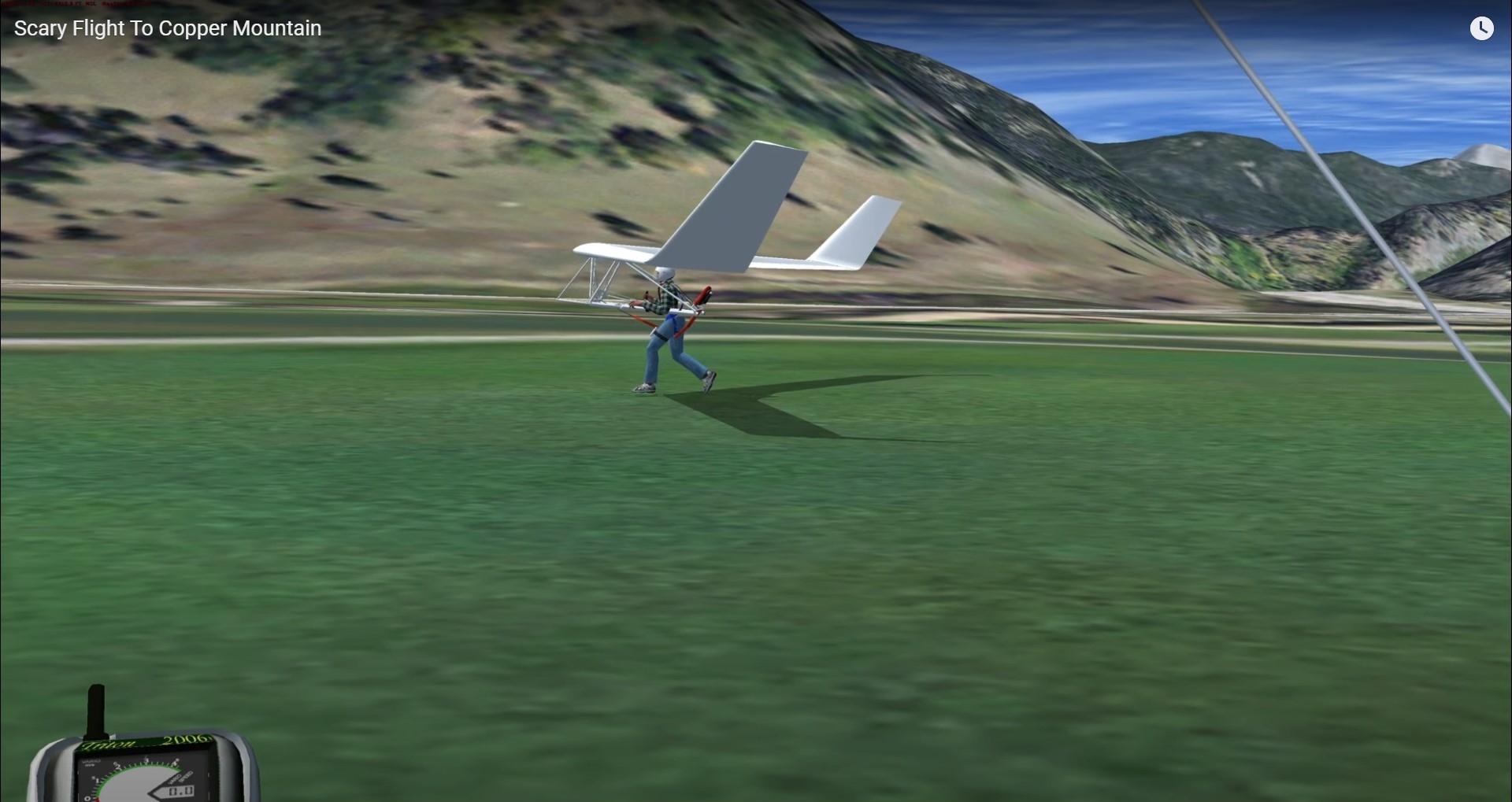
Our LZ was the golf course at the base of the mountain. Seagull landed first in a strong wind and just floated to the ground in a no-step landing! I followed just behind and also had a no-stepper!
What an awesome flight. About 1 hour 20 minutes to complete. 30 miles is all, but way too much fun.
Let’s talk about some of the technology:
This part of the article describes the technology we used to make this video and where we plan on taking this technology. I could explain to you that on the entire planet Earth, for it’s entire 4 Billion year history, nobody has actually simulated hang gliding, especially cross country flying, like it is done in this video. Others have flown gliders, sailplanes and even hang gliders, I give you that for sure. But no one has ever done what you see in this video. We aim to do better.
Computers
2 Pilots. 2 Computers.
I am using a 5-year-old HP Envy all in one computer. It has a good processor and memory, but a sub-par on the motherboard, video card. I use it for software development, not games! It is a miracle it can even run this app.
Seagull is using a brand-new HP OMEN desktop computer with an 11 Gen CPU, 64 Gb of memory, a RTX 3090 graphics card and all the bells and whistles. I will soon have the same computer!
Software
I will leave out the details of all the add-on software we are using (and it is a lot!), the main thing we are using is Microsoft Flight Simulator – Steam Edition. Last updated in 2006. Yet, this is all we found that would allow us to experiment!
What is amazing, is that both our computers render the simulation in an almost equal level of detail. Not the same, but close. Seagull’s computer will show moving traffic on the highway and whitecaps on the water when we landed, and more details in the distance. But the general experience is the same. That tells me we have pushed this experiment to the edge and there is no further we can go as far as providing a valid visceral experience. Which is our goal.
Future Software
We knew when we started this discovery, that our goal was to use new flight simulators. We watched the videos of the new Microsoft Flight Simulator – 2020 and the scenery detail was mind blowing! But it had a lot of missing features. It did no support soaring, in any format! It did not have thermals but did provide some ridge lift mechanics. The weather and cloud rendering were also miles ahead of the tech we were able to use. The developers of MSFS promised sailplanes (and by reference thermals/weather) in the 3rd quarter of 2022. This got us motivated! We purchased new computer equipment in anticipation of being ready when it launched. Then they started really supporting Virtual Reality (VR) in the simulator. We had to do that too! So, we purchased HP Reverb G2 headsets, again in anticipation of being able to try this type of simulation in VR.
Free Flight Experience
Then we found another explorer! The Free Flight Experience! This is a hang-gliding specific simulator for VR! The videos of the developer making progress where astonishing! He eventually opened the software up to Beta testers and we signed right up! This is all very new to us, but follow along as we discover what kind of flying experience we can achieve on this platform as well.
What you can expect from us on future flights
First. We will both be flying using the high-end computers and most probably in VR most of the time. We will be exploring both MSFS 2020 and Free Flight Experience. We can do multi-player in MSFS but not TFFE (yet). We can fly Hang Gliders in TFFE but not MSFS (yet). We have soaring in TFFE but not in MSFS (yet). We will also continue to fly in FSX, I would wager. At least for a short period of time.
Let us compare some renders
These screenshots are various images we have taken or sampled from the above software/hardware platforms. I am showing them here to give some perspective of the current state of technology and the convergence we think that will happen soon.
FSX – Crap video card
Copper Mountain, CO

TFFE – RTX 2080 TI (screenshot)
Mount Diablo, CA
FSX – RTX 3090
Ten Mile Range, CO

MSFS 2020 – RTX 3090
Lookout Mountain, CO
The TFFE and MSFS screenshots are both from VR flights in the two different platforms. The other two are from our existing systems, and are in fact from this flight.
The FSX analysis
There are obvious limitations to the limit of detail here. The RTX 3090 can drive more detail but does not make the detail any clearer. It can simply just render more terrain and some levels of animation.
If you try and fly FSX anywhere that there are not photo-realistic maps available for download, you will be sorely disappointed in the results. This puts limits on where you can fly. Flying from real world sites in non-photo real areas is usually impossible and not worth doing even if it is.
Sounds and animations are defined by the Glider model itself. Some are very basic; others have some more intricate details. These models are as old or older than the simulator itself, so they are what they are. And there are only 4 to choose from and there will likely never be any more. These gliders are not really ‘gliders’, they are airplanes with engines (and limited fuel) to the simulator. That is how they take off. Very clumsy and difficult to work with. We solved that.
The details of the gliders are basic too. You do not have to look closely to see it is just a cartoon. Notice the white tube in the FSX – RTX 3090 shot. It glows, and when you look up at the wing and fittings, everything is just a plain white.
There is no VR for this simulator, but we do use an Infra-red head tracker that at least provides some realistic view changes and goes a long way to making the flying more enjoyable.
Weather is primitive or you might say virtually non-existent. It will render weather (globally) based on METAR weather strings formatted to a specific format. We built a whole system for that.
All flight control is done via standard joystick.
The Free Flight Experience analysis
I can not speak of the level of detail as I have not experienced it firsthand yet. But from the videos, it has some limitations. Gliders are much more detailed and accurate. Visually quite good. Animations are way beyond FSX models and go a long way to accurate hang gliding.
There are ground level details around the launch and landing that add to the realistic effects. Windsocks look and behave like windsocks for example. Gliders on launch and the ground also look and react in realistic ways. The terrain modelling is above that of FSX, but still has a lot of 2D rendering up close. It does include the entire planet, but I do not know at what level of detail yet. (important). The flight mechanics are very realistic, so much so that it will take some training for non-hang glider pilots to use. That is a good thing. Seagull has flown a few test flights so far and he is excited about the possibilities! He flew from Mt Diablo and said he was exhausted afterwards, and his heart was pumping. That’s what we want. Any real Hang-Gliding experience should produce just such a reaction.
Wind/Weather appears to be very detailed using weather sounding reports to generate conditions. Very good data should produce very good results. But that depends on how weather is rendered in this simulation. We will find out.
The soaring model (ridge and thermal) seems to be quite developed in this simulator already! This is a huge plus when flying in this simulator. This is no easy feat. We want to find out how real it is and we can only do that with flying.
Control is accomplished using the VR hand controllers. This leads to a much more realistic use of hands/arms as the control mechanism but can lead to tired arms and a disconnect of your arm/hand placement in real-life and those in the sim. We have ideas about this.
This is still very early days on our discovery journey with this simulator. We know the developer is putting out new features all the time and we fully support his efforts in any way we can! I think you will be seeing some update report videos from us soon.
The MSFS 2020 analysis
We have not soared in this simulator at all (no one has in a realistic thermal). Oh, you can create static thermals and fly around in those with sailplanes, but that is not soaring. Not even close. You can also soar in mechanical ridge lift but this has limited reality as well.
This simulator has all the eye candy! Great renders and details. Photogrammetry makes buildings and other 3D objects appear everywhere! Cars, boats, trees, houses, buildings, mountains, streams, everything. For the entire PLANET. I can not emphasize enough how important that is to simulate realistic hang gliding. It also has extremely well rendered volumetric clouds, shadows, and weather conditions. Again, extremely important to simulate hang gliding. It supports VR as well, and I think that is also going to be very important for anyone trying to experience hang gliding. As that is our only goal, that also becomes very important.
It can be run on a game console: XBOX. This greatly increases the total addressable market of potential pilots. It can even be run on mobile phones and has over 80 million active users. If only .000125% of those people try a hang glider in their sim, that would be more that all the worldwide active HG pilots today. Sad that this is not a made-up statistic.
But it is missing some very key components:
It does not natively support soaring aircraft. By that I mean airplanes without motors. Not just motors that are turned off. No Motors. These can of course be built, and sailplane versions do exist today. Hang Glider versions do not currently exist. Also, a flex wing hang glider is a flying wing; they have no tail, elevator, rudder, ailerons, flaps, wheels, or spoilers of normal craft. It is important.
It does not natively support convection (thermals). Real world random thermals are what make Cross Country flying (like this video report!) possible. Finding a thermal (it is invisible!) can be difficult. It helps that thermals are often connected to clouds and cloud development. That they move with the wind. How high they go or when they start, and stop is dependent on weather and local conditions. Pilots need to be able to use visual clues to make flying real.
VR controllers do not work all that well in general aircraft with knobs and buttons and sticks and stuff. Hang gliders (outside of rigid wings) are controlled by hand/arm movements and VR controllers do just that. Will this simulator support them in this manner? Probably not, but I imagine we can make it.
We will be shooting videos as we attempt to bend MSFS 2020 to our will. Trust me, we can, so watch for those videos soon too.
The forgotten Ground Level detail
What is kind of counter-intuitive, is that ground level views are important. For every other kind of aviation, that would be correct. But it is NOT DONE correct for Hang Gliding. Aviation Simulators usually get the ground details wrong.
This type of aviation almost always starts from some hillside, roadside, cliffside, somewhere out in the wilderness. It is not usually a built up area and so most simulators do not bother showing any details in these areas. But hang glider pilots need to see 3D detail when flying low and they fly low a lot. This dimensionality is what allows them to judge distances as they soar a cliff face or next to some mountain scratching to stay up. It is integral to make this real.
Landing is the same. Landing areas are generally not where you would expect to find them and mostly from the air, everything looks unlandable! But as you get closer to them, you can make out fine details like trees, fences, rocks, and especially slope. This requires that the pilot can see and determine those 3-dimensional aspects of any out-landing area to be able to realistically go cross country. You can always land in the specified LZ for any site, and that is what usually happens, but to land out requires that the simulator renders enough detail in every scenario and every location as much as possible.
MSFS 2020 – Lookout Mountain CO launch site on the ground.
This is raw footage of what it looks like at ground level in what is essentially a random spot on a random mountain. There is depth to the vegetation on the ground. If you look around, there are bare spots and rocks. You can see some 3D trees rendered on top. You see an accurate representation of the launch. It really does look just like this. To a point. There are no trees on top of this mountain. It does not show a guard rail on the road below. The are some rock outcroppings not shown. There is a power line just off to the right of launch that is not depicted. This spot also represents a landing area as top landings are done here regularly, and I think with this level of detail I could pull one off at least as good as I can in real life.
Can it be made better? Sure! But the key is; does it look good enough with no help at all. And it does.
MSFS 2020 supports user definable content such as modified scenery. That is going to be a big asset.

TFFE – Mount Diablo CA launch site on the ground.
I took this screenshot from a YouTube video, so cut it some slack (that is the fuzziness). Behind the pilot here are some static gliders and a very detailed radio tower and parking lot. I am sure the developer built up this site with those details.
The windsock you see is accurate and animated. This addition is also a necessary feature of any ground level launch.
But the ground itself is not dimensional. There are bushes out front (good), and the hills themselves provide proper dimension, but the vegetation on them do not. Will this work? Of course it will, and at any altitude you cannot make that same assessment.
Out landing, and therefore cross-country potential, is yet to be determined. It will certainly be better than FSX ever was and in VR, things generally look much more 3D than what we see recorded in 2D.

FSX – Copper Mountain CO on the ground
In this shot, we see another glider (rendered correctly, for once). Sometimes we find other gliders above us or below us when we are both on the ground when we fly multi-player! Why? Each of us has modified our simulator with outside downloads to make this even possible and there are differences in these modified meshes! If you saw this exact spot in native FSX rendering, you would not be able to identify a single thing around you. Just squares of different colors. To be fair seeing a TBM 930 floating ten feet in the air above you in the parking area while in multiplayer MSFS 2020 is also a common event.
I include this example so that we have something to measure from. You can see that the TFFE ground visualization is miles better than FSX! But it does not match MSFS 2020. Perspective is relative.
We can see the hillside in the distance. We get some sense of distance, but not really. Bushes and other vegetation are very 2D. We are standing on a golf course next to an Interstate Highway and a river. You would never be able to tell that by looking around. There is no slope or depth to the ground of any kind at this level. It is a complete 2D world on the ground. Watch the landing sequence in this video to get a good idea of what I am talking about. It is doable, but barely.
What does the future hold?
Well, things are going to get very cool, very fast. And we aim to help.
First thing that happens is that we will get new gliders. Lots of more gliders. This is very necessary! I would like to see if we can get glider models that are more like personal property that we can move from platform to platform.
Then we need lots of new sites. Both general sites and detailed, hand built, sites. These are coming! I would like to manage my own site list, share with others and be able to fly those sites I already have, on any platform. We need as huge a variety of sites as possible. Beach dune gooning, Cliff launches, ridge soaring, deserts, mountains, the Alps, anywhere! This will take a community effort and nothing short of that will do.
Then we need Wind/Weather/Clouds. We see this happening now. This just needs to be done in a realistic way, do it right and I am there to fly! And most importantly is to be able to fly real, actual, weather.
We need to be able to fly Cross Country. This is where the fun and adventures are. After flying your local site, you want to see what you can see! We encourage that! Get high, Stay high, Fly far!
We need VR! What has been seen cannot be unseen! It is the way to go.
We need good multiplayer. Flying is more fun when done with others, but generally the simulators are bad at this. All pilots need to be flying in the same weather at the same time in the same season even.
We need multiple platforms. Let’s get everybody flying gliders! To do that, you need realism but at different levels of difficulty. From 2D flyers using an XBOX, to VR pilots flying in fully built out physical simulators, and everything in between. Just make sure it is always a realistic experience! This cannot be done in a single platform, nor should it.
We need pilots.
I don’t want people to watch hang gliding. That is ok of course, but I want people to have the experience of hang gliding.
