Scanning for virtual reality

Figure 1 Virtual Representation of an actual flying site
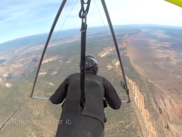
The simulators today are doing a great job at building and rendering random geographic places on Earth (aka a Flying Site). This in of itself is quite remarkable. But to anyone who has visited that exact location in real-life knows that the rendering is only a representation of the real place, not a 1 for 1 copy. For the sake of making things more realistic and immersive, I have been on a mission to visit some random sites in the western USA and see if I could capture some 3D object/pictures of real-world sites and see it that information could be used by us when we start creating flying sites for use in virtual reality.
Take the image above. At first glance, it is rendered beautifully and looks remarkably realistic and accurate to the real world. But in our VR point of view, we will be standing on the ground at launch and be seeing details from a much closer distance. For anyone not familiar with the site, the standard rendering will probably be fine, but for someone who flies this site regularly, you notice what is missing.
There should be a guardrail on the road. You should see windsock and/or tell tails in both the LZ and around launch. You should see cars/trucks parked at launch and the LZ. You should see gliders in the setup area in various stages of setup and readiness. Those little details go a LONG way to general immersion. And not all sites have the same requirements. Some have campsites. Some have different items such as ramps, or specific launch details (like rocks and trees) that make the site challenging. Some generated sites have too many or not enough trees or not in the right places to accurately simulate the realities of a specific site.
To accomplish this, we are trying to see if we can create a library of 3D virtual reality objects that anyone can use to help enhance a flying site that they create and share for others to use. We will concentrate on doing this in MSFS 2020, but we are open to other platforms too.
Technology
We could do this ”Old School” and just start building 3D models from scratch. That was a daunting task and may be even necessary at some point, but we are trying to push the boundaries with this project. We decide to test out the ability 3D scan the real world directly.
We attempted using some on-line software that used image captures and then have that rendered into 3D objects. Yes, that is a real thing. It works but requires lots of high-resolution detail pictures taken in a narrow range of motion. We felt the output was not worth the effort.
We then turned to using the iPhone13 PRO phone. It has an amazing camera and in addition to that it has LIDAR scanner. What the actual?
Surely, this had to be a toy version and not capable of real scanning, but we would try it out anyway (I needed a new phone, so this was just a factor in that decision!). Turns out the best software to do the captures, rendering and exporting turned out to be free. We are using the software SCANAVERSE.
It takes practice to get good scans. Lighting is very important and the darker (yet still fully visible) the better. Reflections of any kind cannot be scanned so bright light tends to create ”holes” where reflections occur in your subject. But great results can be had.
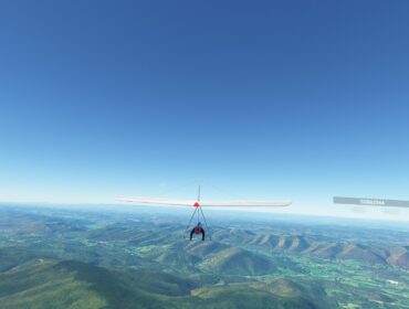
Press PLAY on the video below for an example scan in 3D.
Figure 2 3D scan fly around view

Figure 3 3D scanned fire pit example
The net result is that we can capture photo-real, size accurate, 3D scale models of almost anything. I was blown away.
These objects can then be edited (if necessary) in other tools such as Blender (also free) and then used as visual objects in site(s) within the simulator or any other VR environment. Once placed into a virtual location, you can ‘walk’ about that location in VR and you will see that 3D object, rendered, as you see it above in your virtual world. Think about this for a moment. This will go a long way to building immersive experiences for us and hopefully others to get the feeling of being in an actual place when on the ground. It does almost nothing for the in-air experience in general, but it makes takeoffs, local flying and landing much more immersive and enjoyable.
And anyone can do it given the tools and motivation.
Next Steps
With a viable scanning technology in hand, and some success in importing those objects into Blender and into VR scenes, we feel confident that we can be successful in injecting them into the scenery developer systems within MSFS 2020 and create some very exiting sites.
Attempts at using ground feature scans.
In the above site (Mt. Zion Colorado), the site has a distinctive set of steps that lead from the top parking area past the steep slope of lower launch.
Figure 4 Steps example fly around

Figure 5 Lookout steps example
This image is a scan of that feature. We can place this item onto the site and add that level of specific realism here. We can also just create a library of generic features that could be used on any site.
Glider equipment
Another common element of all flying and flying sites will be hang gliding equipment. This can be harnesses, instruments, and Cars and trucks with racks, etc.
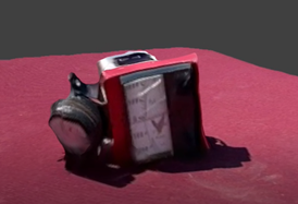
Figure 6 Hummingbird Vario fly around

Figure 7Hummingbird vario example
The above is an example of my old, old, Hummingbird vario and analog altimeter. The only instruments I flew with at the time. With this scanning technology, I should be able to scan multiple vario setups, from all kinds of manufacturers. This will add much more realism into our simulated environment as the more we can make each glider/instruments/sites unique and varied, the more real it will seem to be. Go to any Hang Glider site and look around. No two pilots seem to use the same setup!
Gliders
The last big 3D objects we need to scan are the gliders themselves. We could start from just engineering or CAD drawings and that would be awesome (if we can get them). But not only is that a lot of work, they would probably be too perfect. Getting the colors, the texture, the types of cloth used, is extremely variable in the real world. Hopefully as this project progresses, I can show some examples of captured gliders and cloth textures I capture. Without a doubt, any glider scanned will need to be significantly rectified and refined using a tool like Blender before being usable as an aircraft model in the simulator. It offers a good start to making realistic looking models or at least we hope so.
I will be scanning full gliders, partially setup gliders, gliders in bags, parts details like base bars, down tubes, wire connections, cross bar connections, every little detail. Hopefully we can knit them together into a seamless, detailed, realistic model. Then we hope to be able to create unique versions of gliders even within the same model. This goes beyond a standard livery or paint job. Each glider is a unique combination of model, cloth, age, colors, harness type, and instrumentation. Unlike any aircraft in aviation, a hang glider is unique to each owner and we hope to emulate that.
At some point we hope to share these things with the community. If there is one.
The Sad Truth
I have visited many flying sites in my 2 months traveling the west so far, but I have only seen 1 actual glider (on a truck) at any site I have been to.
When I visited Lookout CO, the last remaining landing area did not seem useable at all anymore as a drainage pond had been installed on it. Paragliders could probably still land there, but not really hang gliders anymore. I went to Williams Peak and you now have to go thru a fence and gate off the main highway (it was not locked). However, the main LZ looked like it had not been used in years. Completely overgrown and no sign of any activity. Not even a windsock. I went to Blue Mesa and saw at least a truck with a glider in the LZ. Are these sites still being flown? I am sure that they are! But not in the frequency or in the same numbers as I remember.
Oh, I will get to some sites that are active I am sure, but it is a lot rarer than it used to be. I am in Washington State now. I can try Chelan but I am sure it will be empty. I will be in Oregon next. Eventually I will be in Utah and the Point of the Mountain surely will have activity. I will update as I can.
Once back in Australia, I know many active sites just near where I live that will keep me busy.
It is just sad to see the slow evaporation of the sport. I can only hope our project brings information about the experience of the sport to more people and that some may choose to keep it alive in the real-world.
We are also exploring VR in depth and have even some VR hang gliding experiences, but we are not yet to point of making VR Experience Videos, but we will be!