
 The Hang Gliding Files PC App
An application to build, create, and share Hang Glider flying sites for use in MSFS 2020.
Hang gliders typically do not take off from airports. Instead, they launch from designated hang gliding locations in mountains, on beaches, or from grassy fields equipped for towing. These environments are not naturally present in MSFS 2020. However, with this application, you can transform any location into a hang glider site, sailplane airport, or airstrip. Utilize our MSFS 2020 Widget tool to teleport to your newly created site. If you lack this widget, follow the link to download it.
The Earth boasts hundreds of thousands of potential flying sites. It’s impossible to create them all, which is why we need your assistance. Create your own sites and share them with us or your flying community. Our app is designed to facilitate this sharing.
Features:
Add/Edit/Modify information about any flying site.
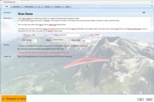
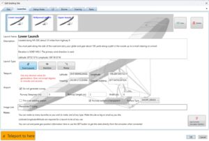
You have the ability to create your own sites, modify any existing ones, and share them with friends.
The simulator can capture site locations, altitudes, and headings directly. This means that even if you begin with a broad area from a map, you can position your glider in the simulator to the precise spot you desire and have the details instantly updated in your database.
Any sites you add to your desktop database will automatically refresh and sync, making them immediately available for use with the widget teleportation toolbar app, assuming it’s installed.
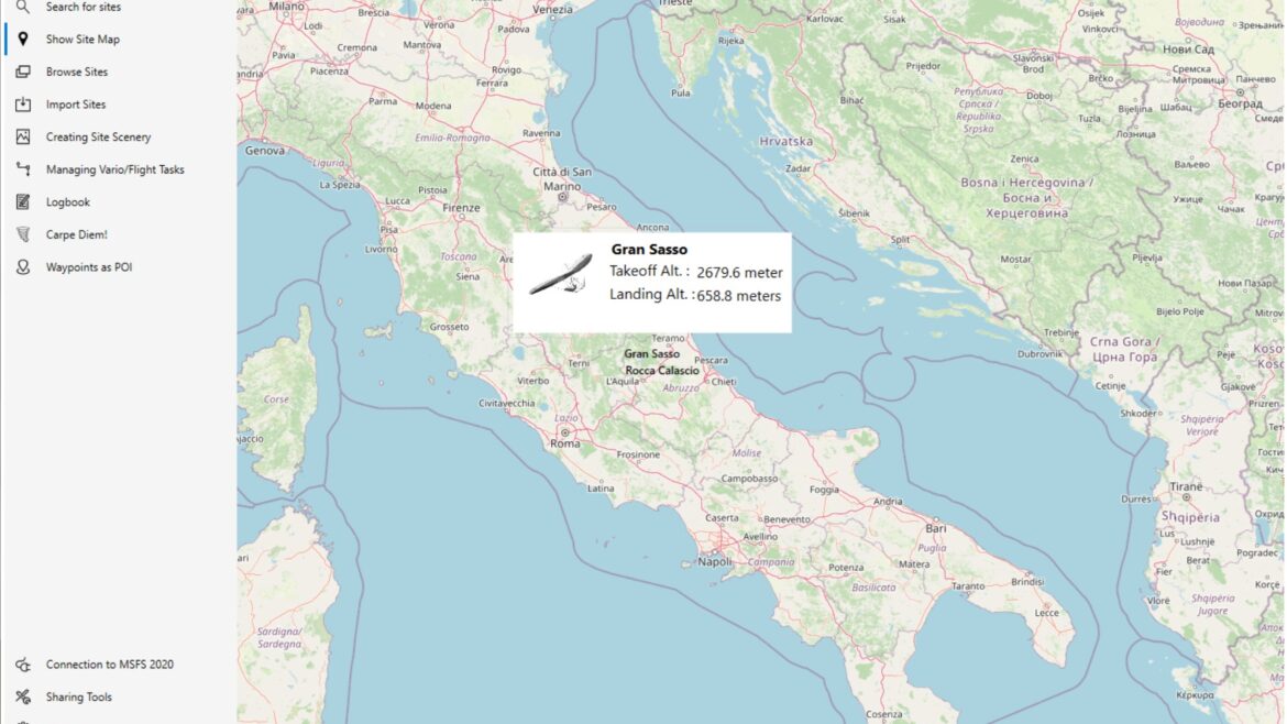
Find sites using multiple search features.
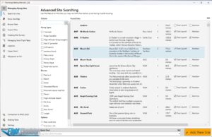
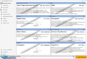
Discovering new and thrilling destinations for flying is quite straightforward.
Create MSFS 2020 site scenery automatically
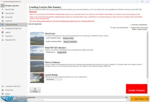
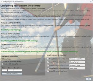
You can transform any hang glider site into a complete scenery package within MSFS 2020. This turns your hang glider site into a functional airport in the simulator, complete with windsocks, telltales, ramps, and even runways if needed. Sailplane pilots can also use this feature to create launch airstrips for sailplanes virtually anywhere, fully integrated into MSFS 2020.
Feel free to add any elements you desire to your site scenery!
While it’s not mandatory, you have the option to enhance your scenery with additional objects.
Include vehicles, gliders, ramps, people, buildings, signs, or anything else you envision. Our framework facilitates this, allowing for straightforward modifications, akin to point-and-click.
You can either design your own objects or utilize models from any library, including our own, simplifying these modifications to a point-and-click process.
Adjust the existing geography and vegetation as needed!
Although the simulator generally replicates the scenery accurately, it can sometimes miss the mark. In such cases, you might need to do more than just add objects. You might find it necessary to remove trees, alter vegetation, change the soil type, or correct roads and parking lots. Our package enables you to make these adjustments. It requires some practice, but once mastered, it’s as simple as point-and-click.
Create and share flight tasks
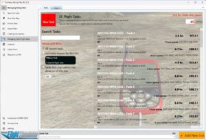
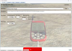
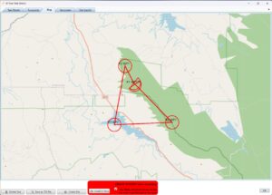
These courses can be created by you, obtained from friends, or sourced from various soaring websites. We adhere to the standard format of XCSoar. Your task files will be integrated into your virtual variometer or directly into your PC’s XCSoar. We have the capability to import and export task files, as well as to import waypoint files for task building, such as .CUP or .WPT formats, simplifying the task creation process. Additionally, this service is available to sailplane pilots.
Keep a logbook of your flights.
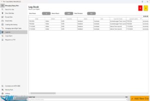
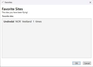
The MSFS 2020 logbook records only flights that take off and land at airports, but we track every launch and landing of your hang glider. We also keep a record of your favorite flying sites, allowing you to revisit places you’ve flown to, even if you’ve forgotten the site names.
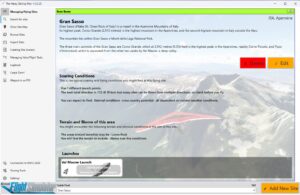
Fly in real-weather conditions anywhere on Planet Earth
Or as we say Carpe Diem! (seize the day!)
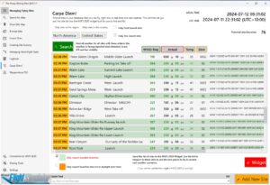
We urge all soaring pilots to embrace live weather conditions for the most authentic and enjoyable simulated flight experience. It’s a challenging endeavor, indeed.
The challenge lies in the unknown: which sites are currently suitable for soaring when you’re unaware of the global weather patterns. Even with that knowledge, determining the usability of a specific site or launch can be elusive. Furthermore, knowing if the prevailing winds and weather conditions are conducive to soaring is another layer of uncertainty. And even with all that information, the local time zone of the site, as well as the actual time of day or night, may still be a mystery.
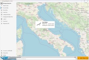
That’s where we come in! Our system simplifies this process. The provided example screenshot above, displays all the sites within a region, complete with their local time, current weather conditions, and an assessment of the weather’s suitability for soaring based on the launch parameters.
Moreover, you can simulate real weather conditions even during the site’s nighttime. Simply adjust the simulator’s time to daylight hours while keeping the real weather feature active, and you’ll still experience dynamic weather with thermals.
This data is then delivered to our WIDGET toolbar app within the simulator, forming a handpicked list of sites. There’s no need to search; the two applications integrate flawlessly to launch you into real, dynamic, and soarable weather conditions, just as actual pilots would.
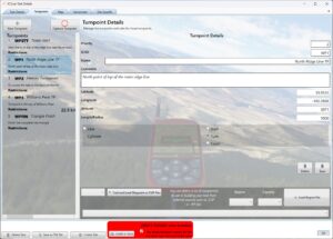
Manage your own waypoints database.
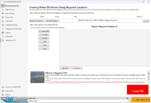
Flying tasks with friends is a lot of fun, but building them can be less so. We simplify this by providing tools to easily construct tasks. One such tool is the waypoints database.
You can import predefined waypoints from numerous sources on the web into a general region/country/state database. These waypoints then become readily available for any task you wish to create. Additionally, any waypoints you personally create are stored within these databases.
Why is this beneficial?
Firstly, it eliminates the need to repeatedly find and download information. Everything is accessible within the app, allowing you to select a waypoint from the database and add it to your task with ease. However, the real challenge lies in crafting an engaging course. This can be achieved by selecting points on a 2D map and testing their viability in 3D, or by exporting your waypoints directly into the simulator as Points of Interest (POI). Within the simulator, using the slew function and your game controller or joystick, you can navigate the area in 3D and visually locate each waypoint. This app enables you to capture existing waypoints (or add new ones) as you envisage navigating any conceivable course. The end product is an XCSoar-formatted task file, compatible with our variometer/flight computer or XCSoar itself (both in real life and simulation), or it can be converted into an MSFS 2020 Flight Plan for use with existing sailplane navigation systems.
Other things:
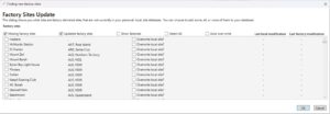
Import site information from other sources. These could be files shared by your friends, sites you download from this website or any other source that can create the proper JSON formatted file.
Share your site or sites with anybody by creating a JSON file that you can give to anyone.
Share your site with us (THGF) directly using email. Right from the app. We will include your site in the next app update!
Download the ZIP file and extract the installer application.
Once the ZIP file has been extracted, just run THGF.exe installation and follow all instructions.
If this is an upgrade to a previous installed version,
PLEASE NOTE: Your existing data will remain intact and not be changed. You will not get any new site information automatically. You can upgrade your local site database from the new factory sites by using the IMPORT feature within the app and import sites from the factory settings.
If you are updating your existing application, remember to check for new factory sites!
The install will not overwrite your existing database of sites. This allows you to create and manage your own personal site database. But you may want to see what other sites pilots have been creating and sharing. Each updated version is likely to have many new sites. Check them out.
Release Notes
4.0.2.5 October 6, 2024
- Added 3 new sites that custom scenery can be downloaded from flightsim.to
- Some bug fixes related to task creation.
- Modified ground handling. Handles models other than foot launch gliders (think Trikes, etc)
- Improved map rendering in variometer/flight computer
4.0.2.4 August 25, 2024
- Added 4 new sites that custom scenery can be downloaded from flightsim.to
- Some bug fixes related to site creation.
4.0.2.2 July 12, 2024
Cycle 4 release notes
3.0.4.5 May 10, 2024
General enhancements and bug fixes:
- Fixed layout on task turnpoint page
- Fixed useability on map page.
- Added clear search button on search page and it now goes to the site detail page when a site is clicked.