Kirra Beach
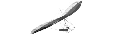
Specimen Sheet · Vital Statistics
Classification · Terrain & Access
Field chart.
§ 02 · Flying Conditions · Field NotesUpdated 2026·03·21
Kirra Beach is the home site of The Hang Gliding Files, a low-lying coastal launch on Queensland's Gold Coast just metres above sea level. Its flat beach foreshore makes it an ideal tow site, and the consistent northerly sea breezes combined with thermal potential over the hinterland make it a versatile training and recreational flying location. The beach setting, proximity to the famous Kirra point break, and open airspace over the water give it a distinctive atmosphere that blends sport aviation with classic Australian coastal scenery.
With at least one defined tow corridor and a single primary launch point, Kirra suits aerotow departures heading inland or northward to access developing thermals over the low coastal plain and suburban hinterland behind the dune line. Thermal triggers include dark road surfaces, car parks, and the patchy scrub and rooftop zones of Coolangatta and surrounds — expect broken but workable thermals from late morning on sunny days. Ridge-style lift along the beach face is limited given the minimal elevation, so tow height and thermal hunting are the primary path to extended flight. Cross-country options exist heading north along the coast toward Surfers Paradise or inland toward the Lamington Plateau, though airspace awareness around Gold Coast Airport to the north is essential.
§ 03 · Wind Window · Best Operating EnvelopeN · 350° ±0°
The prevailing best wind is from 350° at 10–20 knots, a light northerly that runs nearly parallel to the coastline and provides a reliable soaring window along the beach face. Queensland's subtropical climate means thermals can develop strongly over the backing land by late morning, while sea breeze cycles often stabilise conditions in the afternoon. Pilots should monitor for southerly busters and the possibility of onshore easterlies that can shift the wind window significantly, particularly in spring and summer.
Chase the Wind
Real-time METAR data helps you find a good conditions window and set your MSFS world clock to match.
Weather data temporarily unavailable.
§ 07 · Location · Field CoordinatesWGS-84
§ 09 · Recent Flights · Log Book
No flights logged at Kirra Beach yet.
Be the first to fly here, upload your IGC file, and set the site records for others to chase. Every flight logged helps build the community data.
Upload a flight →